Hacking Your Environment: Exploiting Undocumented, internal APIs, Part I
I’ve recently found myself obsessing over the seemingly infinite ways to hack my environment by extending and improving upon applications I use everyday. As a college student I find myself using gmail quite often for anything from chatting with professors, to more recently, getting a hold of friends while my phone is broken. As a developer I tend to use many keyboard shortcuts, both on the web and while crafting code. When I realized that Gmail’s web version had no logout shortcut I built a simple fix called Gkey, which allows users to logout of gmail by pressing ctrl-L - free to download via Chrome Web Store. This is just one example, but can help get you thinking about ways to extend your apps’ functionality.
Adding a feature or two to a web application by injecting javascript into a page can be really fun, but don’t forget that we are developers, hackers - the architects of the future. We possess the knowledge and tools to truly change the universe.
Universities provide many awesome things for students - dorm rooms, cafeterias, classrooms, even gyms. The problem is that many of these goods are durable and can be hard to improve. Your dorm room is too small? You could knock down the wall into your neighbors room, thus making it a penthouse, but I don’t think that would go over well with the housing department. You know lunch in the cafeteria would be more enjoyable if they provided Tapatio instead of Cholula hot sauce (me too)? You could always bring some for yourself and maybe you friends, but this would prove pretty difficult and expensive to scale to the rest of your school, especially if it has 33k+ students such as Boston University where I attend. Besides tangible goods, schools also provide many software solutions to existing problems. If you’ve attended university recently you have most likely browsed and chosen classes via some online application. You might have also recently used services such as printing via software your school provides. Just as you did with your dorm room or cafeteria, I’m sure you or your friends have thought about ways these services could be vastly improved. Lucky for us these services are all digitcal and run on code written by people no smarter than you or me. With just a little bit of digging I’m sure you can find ways to leverage their existing architectures to make them behave how you would have designed them had your school paid you - most likely very, very large sum of money.
In this post I’d like to go over a recent, ongoing project of mine that involves creating a new and improved BU Bus app using existing (non-public) APIs. The BU Bus is a free shuttle that takes students around campus. The existing Bu Bus App shows students in real time where the buses are and the various stops they can get off at. The problem with this is that there are many more ways to get to classes, including MBTA buses, trains, Uber, etc. If all of this data is available then there’s no reason students shouldn’t be able to compare all of their options, ranked fastest to slowest, and chose which method suits their schedule best when heading to class. This is the problem I’ve set out to solve.
Existing live view of the BU Bus app
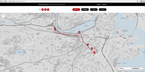
The first you’re going to want to do when thinking about building on top of another platform is to use the app as you normally would and simply figure out the basic architecture. The first thing I notice when looking at this live view is that the app is using a Google Map to display the bus locations.
We know this by noticing Google in both the bottom left and bottom right corners of the map.
Having worked with Google Maps before I know they have awesome APIs for plotting latitude/longitude coordinates, so I can take a guess that they’re using one of the Google Maps APIs.
Since the map is realtime and rendered asynchronously I believe that they’re using the Google Maps JavaScript API - currently v3. Now that we know what service they’re using to plot the coordinates, the next question we must ask is - Where is the app retrieving the bus data containing the longitude/latitudes of the buses from? The most common way for apps to communicate with each other is through an API, or Application Programming Interface, and this is my first guess as to where the data used in the map is coming from. So, the next thing to do is to see if we can locate any of the endpoints of this possible API so we can consume the data in its raw form.
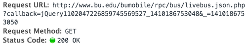
A good place to start is by opening your developer tools in your browser of choice - I happen to be using Chrome and can do so with option-command-i. The Network tab shows all of the HTTP requests and responses to and from various resources.
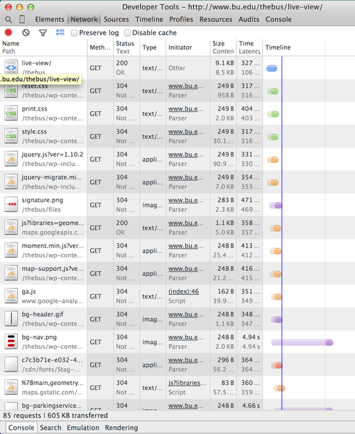
Each column represents a response. We are looking for a column displaying a GET request to some endpoint that returned a 200 status meaning successful. Scrolling down through the columns we come across this livebus.json.php file, which stands out to me for a few reasons.
-
It is named livebus - This filename tells us that it most likely has to do with a bus and possibly live data about said bus (sounds like something we might be interested in)
-
It is saved with a .json file extension. JSON stands for JavaScript Object Notation and is one of the two most common data formats used to interact with APIs - the other being XML.
-
JSONP - if you look in the left column you will see the Request URL ends with ?callback=jQuery110204… This actually has a lot of significance. It shows that the client is using JSONP to request the data, a technique used to request data from a server in a different domain, which is actually prohibited by most modern browsers due to the same-origin policy.
-
IP Address: The Remote Address is 128.197.26.3. Navigating to this in a web browser shows it is hosted on one of BU’s servers.

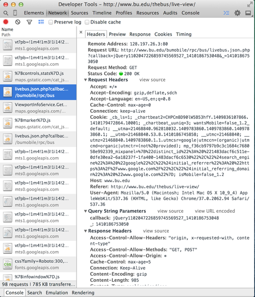
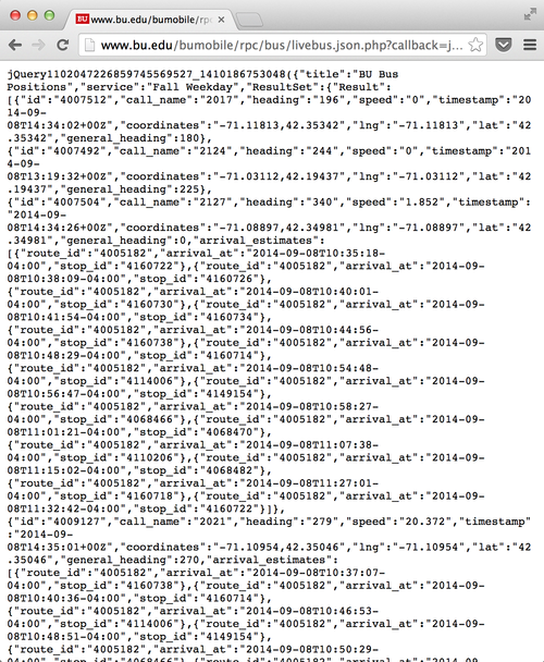
Taking all of these points into account, it looks like we might have just found the elusive API. The only option left is to request this resource, which can be done by navigating to the Request URL in your browser (essentially sending a GET request).
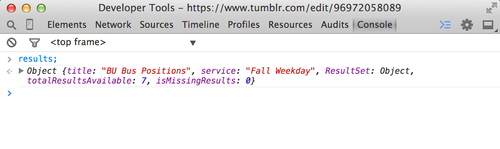
You’ll notice below that we are served a page full of JSON and if you look closely at the first attribute - “title” you’ll see that its value is “Bu Bus Positions” - SUCCESS!
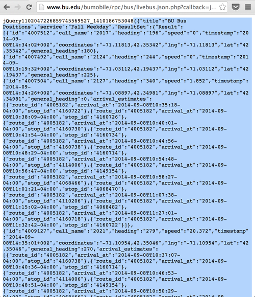
While this big blob of JSON is a lot of fun to stare at, we are developers, and as developers we work with code. Let’s highlight this mess and save it to a JavaScript variable so we can start diving into what we’re working with.
Opening our Chrome Developer Tools and saving the JSON to a variable named results we can begin parsing the response.
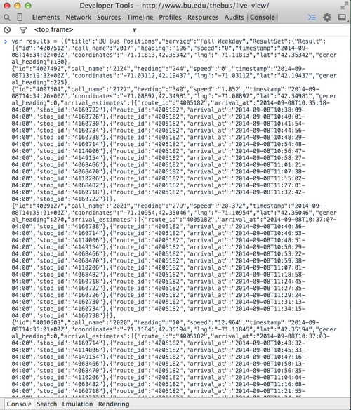
The Dev Tools give us a much cleaner interface for working with this data. We can see a couple of attributes - title, service, ResultSet, etc.
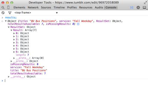
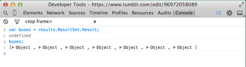
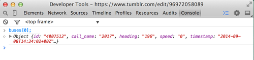
Expanding ResultSet and then Result we notice 7 objects, numbered 0 - 6, which turn out to be the 7 BU Shuttle Buses currently in operation.
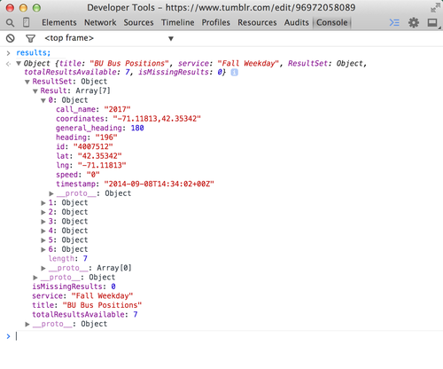
Diving into the first one you’ll notice we can get a lot of good data from each bus including a latitude (lat), longitude (lng), speed, callname, general_heading, etc.
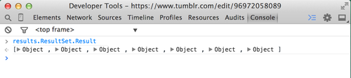
To get to the array of buses we called ResultSet followed by Result. Let’s
save this to a variable, buses. Now, to access the array of buses we can call
buses instead of having to call results.ResultSet.Result. This helps both now
and down the road when we forget what results.ResultSet.Result actually
returns.
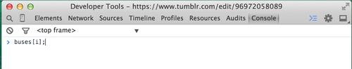
We can now access each bus via its respective index. So for the first bus we can use:
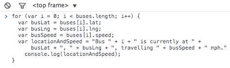
Looks like a prime time to use a simple for-loop to iterate through each element (bus) in the array and extract some data about each.
Programming is all about minimizing complexity. Let’s make this program a little more readable/maintainable and extract some variables. We’ll get each bus’s respective latitude, longitude, and speed and save these to variables we’ll call busLat and busLng, and busSpeed. By concatenating some strings with these variables we can piece together the locationAndSpeed of each bus and log this to the console. Executing this loop provides the following output, exactly what we need to start plotting the coordinates on our own map.
Software projects are best executed in multiple steps to limit complexity. This is just the first step in a longer process of piecing together a fully functioning application. Every day we are presented with opportunities to improve existing platforms and I challenge you, as the reader - the developer, to go out and seize these opportunities. Don’t be scared to build some shit, and sure as hell don’t be scared to break some shit. Stay tuned for part II and feel free to reach out with any questions/comments:
@askwheeler